Take a walk that combines two contrasting waterways: the broad reaches of the River Severn, and the rural meanderings of the Droitwich Barge Canal

Until six years ago, following the towpath would have been the only way to enjoy this month’s route from Worcester to Droitwich – but all that changed in 2011 with the reopening of the Droitwich Canals to navigation after almost four decades of restoration work. So now you can make the journey by boat too; however it’s still an enjoyable walk, enlivened today by the passage of boats rather than the chance to catch up on restoration progress.
But we’re getting slightly ahead of ourselves: the first three miles follow the River Severn, starting at the 1781-built five-arch main road bridge near the centre of Worcester city. Although our walk follows the east side of the river, you have the choice of following the west bank for the first quarter mile before crossing on a footbridge: if you take that route, do make sure you cross the bridge as it’s seven miles to the next one – in fact the navigable lengths of the river are noted for the scarcity of crossing points.
Assuming you choose the east bank, you will start out along North Parade before bearing left onto a footway where the road leaves the river, descending a flight of steps to follow the riverbank past the town moorings and rowing club, with the racecourse above you to the right.
It all looks very rural and you could be forgiven for thinking that the city has been left behind, but in fact you will pass through more of the built-up area first. The path turns right, away from river, and a gate on the left leads into Waterworks Road, which also turns to the right. Where the oddly-named Pope Iron Road turns off on your right, turn left along the path opposite. This leads to Tower Road: turn left, follow it round to the right; keep straight ahead where it bends to the right again, and continue along a footpath. Another footpath leads off on your left, and brings you back to the riverbank at last. Don’t worry if this sounds complicated – there are signs to guide you.

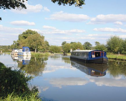
After that, it’s easy: the path may be indistinct in places and there are choices of route at times, but you just need to stay close to the river as it meanders northwards, finally leaving Worcester behind. Passing Bevere Weir (with a glimpse of the lock on the opposite bank, along with the frustratingly impossible-to-reach Camp House Inn), the path eventually leaves the river and meets Hawford Lock Lane. Turn left, and the lane turns into a dirt-track which ends near a flight of steps leading down to the lock – the first on the Droitwich Barge Canal.
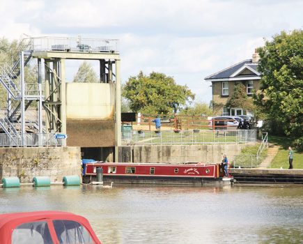
From here you’re on a ‘proper’ towpath at last, heading eastwards away from the Severn past a second lock (where the path crosses to the opposite bank) to reach the A419 main road bridge. This was one of the last major obstructions dealt with when the canal was restored: the result was a tunnel-like concrete bridge which won’t win any architecture prizes, but it does the job – and includes a towpath, so you won’t have to cross the dual carriageway.
By contrast, the next two miles are the remotest on the canal, which winds its way along the quiet Salwarpe Valley with little sign of habitation and just two bridges. These include Linacre Bridge, an original dating from James Brindley’s construction of the canal in the 1760s and still bearing the scars of the occasional scrape from the masts of sailing barges which used the canal in its early days.
Civilisation returns at Porters Hill, with a road bridge and a lock cottage beside the first of the flight of five Ladywood Locks. A second cottage marks the top lock, then another quiet rural length leads to the tiny Salwarpe village. Boaters will scarcely notice the canal crossing the Salwarpe Brook on a large culvert passing through a high embankment, as there is no narrowing of the channel and trees conceal the steep banks; however walkers can scramble down to inspect the structure which took up a great deal of the restoration volunteers’ time in the 1980s.

The only embankment on this typical Brindley contour canal is followed by its only cutting, passing under a tall bridge which leads to the mediaeval Salwarpe Church – worth a detour to see it.
From here it’s only half a mile until the outskirts of Droitwich begin, but although on the right hand side the canal is accompanied by housing estates, on the left bank the land between river and canal is undeveloped, with a community woodland, nature reserve and sports fields reaching all the way into the town.

The second of a pair railway bridges on the approach to the town centre is another structure which won’t win any beauty prizes, consisting of a large metal tube between two functional concrete portals, dating from the 1970s. However it too marked a significant stage in the canal’s revival: that a navigable bridge was provided at all in the early stages of restoration was a great step forward.
Railway enthusiasts will note the impressive surviving signal box and semaphore signals still in operation (but perhaps for not much longer, as re-signalling is proposed); enthusiasts for a different kind of ‘railway’ will be able to take advantage of the Railway Inn, once a popular haunt of the restoration volunteers.

The pub stands on Kidderminster Road: cross the bridge which carries this road over the canal, turn right into Union Lane, and a five minute walk will take you to Droitwich Spa railway station for a frequent service back to Worcester.
Image(s) provided by:
Martin Ludgate