One of our earliest industrial canals, the Bridgewater was ahead of its time, and its sturdy construction still impresses in its modern role as a vital link in the north west’s leisure network

Today the Bridgewater Canal forms a useful link between the Trent & Mersey, Leeds & Liverpool, Rochdale and Manchester Ship canals – as well as providing interesting and attractive cruising in its own right. But it’s worth remembering that it actually pre-dates all of these, with an oft-disputed claim to be ‘Britain’s first canal’.
It wasn’t the first, by a long way. That honour probably goes to the Fossdyke, built by the Romans. Even the suggestion that it was the first of the industrial canal-building era will be hotly denied by supporters of the Sankey Canal, opened a few years earlier, but often overlooked for reasons including that it is no longer navigable (although the Sankey Canal Restoration Society is keen to put that right), and that it was officially sanctioned as a river navigation – but actually built as a canal.

But undoubtedly the Bridgewater was the one that caught the public imagination, as it strode boldly across the land, bridging the Mersey & Irwell Navigation on a sturdy aqueduct, delving deep into the Duke of Bridgewater’s coal mines at Worsley, reaching into the heart of Manchester, and extending down to the Mersey via a monumental flight of flocks at Runcorn. To look at it today, that boldness is still very much in evidence, especially when compared to the narrow channels and contour-following windings of some of its immediate successors such as the Staffordshire & Worcestershire or Oxford canals. Some would say that this was a necessary economy, after building the Bridgewater to such a high standard had almost bankrupted the Duke. Others like to argue about whether it was the Duke of Bridgewater, his agent John Gilbert, or the hitherto unknown but subsequently famous engineer James Brindley who had the most influence on the design. But whatever the case, the Duke and his pioneering canal certainly made their mark.
The canal effectively had two main lines: the original Worsley to Manchester route (later extended from Worsley to meet a branch of the Leeds & Liverpool at Leigh), and the slightly later route from a junction in Stretford known as Water’s Meeting down to Preston Brook and to the (now abandoned) link to the Mersey at Runcorn. We’re going to start with the first of these, as if we’ve just arrived from the Leeds & Liverpool Canal’s main line via the branch from Wigan to Leigh.

And the first feature of note is how the canal begins: not with a junction, or a stop-lock, or a basin – but with a crane. These are a feature of the Bridgewater, and reflect the generally larger scale that it was built to. Like many waterways, the canal is equipped with sets of ‘stop planks’ which slot into grooves set in the channel sides (typically at bridges) to dam off lengths so that they can be drained for scheduled engineering work, or to deal with breaches or other emergencies. But wider canals mean heavier and less easily manhandled planks, so these hand-cranes are still in use to lift the planks in.

As the canal progresses eastwards through Leigh, there’s plenty to remind boaters that this was an industrial town, with some impressive textile mill buildings still standing, albeit empty or converted to other uses today. Leaving the town behind and passing through flat countryside, there’s a reminder of the area’s other main industry (and the reason for the canal’s construction) in the form of the pit-head winding gear of Astley Green Colliery. After the mine closed in 1970, it was saved from demolition and now forms the Lancashire Mining Museum (see inset).

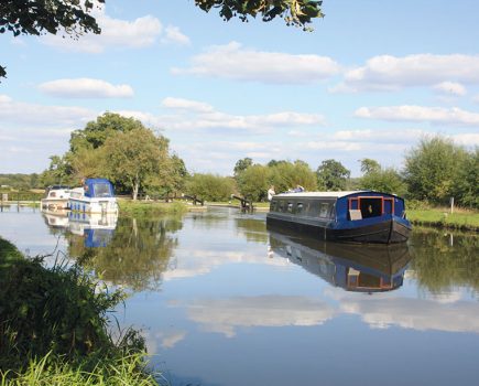
Coal mining ceased completely in the area by the 1990s, but an old colliery basin survives as marina moorings as the canal approaches Worsley, and its original raison d’etre.

A sharp right turn is accompanied on the left by the black and white half-timbered Packet House and associated steps, where passenger boats for Manchester once departed, but it’s the transport of coal that gives Worsley its special status in canal history. The short arm leading ahead at the bend leads to Worsley Delph, a basin in a deep hollow from which two tunnels took small boats right into the navigable mine workings to load coal. At one time these underground navigations extended to over 40 miles, with an inclined plan lift connecting the different levels.

Today this vital piece of canal history looks slightly down-at-heel and overgrown, but a recent Lottery grant is enabling it to be restored, vegetation cleared, and a public viewing platform created as part of a project to help visitors to visualise the Delph in its working days.

Passing some useful visitor moorings on the right and a boatyard on the left, we are now on the Duke’s original length of canal, built to carry his coal into Manchester. We’re also within the Greater Manchester built-up area, and it’s an urban length with a road alongside it which leads to Barton, and another wonder of waterways history.

Brindley’s (or the Duke’s) aqueduct over the Mersey & Irwell Navigation (which at this point made use of the River Irwell) stood the test of time, but in the 1890s the Manchester Ship Canal was being created along the route of the same two rivers – and so a replacement crossing capable of taking ocean-going shipping was needed. The answer was the remarkable Barton Swing Aqueduct, which swivels through 90 degrees on a central pivot (set on an island) to open up a channel each side for ships to pass. Not many ships use the canal’s upper reaches today, but we were lucky enough to see it swing open when we were taking the photographs for this article. (See navigation notes)

Industry surrounds the canal as it passes Trafford Park, credited with being the world’s first planned industrial estate, as it approaches Waters Meeting. Here we’ll bear left to stay on the original line to Manchester, the canal passing under the shadow of Manchester United FC’s famous Old Trafford stadium. The approach to the city is through an unkempt area of formerly industrial land alongside the Manchester Ship Canal, the subject of current regeneration plans. Until those plans come to fruition, it’s a somewhat forlorn and heavily graffiti-covered lock on the left which forms the new link via the former Pomona Docks to the Manchester Ship Canal. Don’t be put off by appearances: even for those not planning to make the journey down the Ship Canal, the upper reaches including the River Irwell make a fascinating out-and-back excursion – but you’ll need to book ahead and pay a fee.

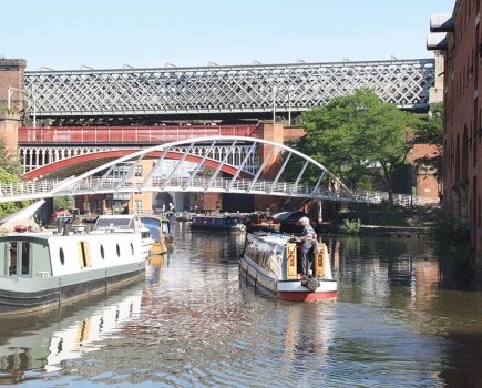
The canal is overshadowed by railway viaducts (some re-purposed as part of the city’s ever-growing tram network) as it approaches the complex of basins and arms which form the canal’s Manchester terminus. Look out for the previous connection to the Ship Canal, the Hulme Locks Branch (abandoned in the 1990s when Pomona Lock was built), the Grocer’s Warehouse (a reconstruction of the canal’s original unloading facility), and the connection to the Rochdale Canal which continues the through route for boats heading over the Pennines or around the Cheshire Ring.

Back at Waters Meeting, we’ll now take the third direction, south westwards on the Runcorn line of the canal. Passing south through Stretford, it then bears south westwards, briefly leaving the built-up area to cross the floodplain of the River Mersey, which it spans on a low aqueduct. A long straight length accompanied dby a tramway line passes through Sale, where a waterside pub features an outdoor patio on a floating pontoon.

Beyond Sale, the canal’s formerly heavily industrial surroundings are gradually being replaced by new housing – including a name familiar to older hands here in the publishing industry. The site of the Linotype factory, which produced machinery for printing in the ‘hot metal’ era, is currently being reused for new housing, with one old building retained for conversion.
The built up area is finally left behind, and the canal heads out into rural Cheshire, passing Dunham Massey Hall and running along an embankment (scene of a notorious breach which shut the canal for two years in the early 1970s) which crosses a series of small aqueducts over minor roads and the River Bollin. In fact road aqueducts are something of a feature of the canal, including a couple of fairly busy ones.
Lymm is an attractive large village with a useful selection of shops, pubs and restaurants, and the canal passing right through the centre. Another rural stretch then leads towards Warrington, which the canal skirts on the south side, passing through Stockton Heath with its handy chandlery and pub.
The countryside beyond is punctuated by the small villages of Higher Walton, Moore, and Daresbury, the latter noted for its links with Lewis Carroll and the canalside Sci-Tech Daresbury science and technology park.
A final mile of rural canal leads to Preston Brook, and the junction where the canal continues ahead to meet the Trent & Mersey (and continue around the Cheshire Ring), while the Runcorn Arm diverges to the right. Or rather, that’s how it’s usually viewed today – but originally, the route to Runcorn was seen as the continuation of the Bridgewater’s main line, and its link to the River Mersey. Even so, the layout of the junction perhaps suggests that a fair amount of trade was expected to continue onto the T&M, rather than take the sharp right hand turn for Runcorn.
We’ve mentioned the broad, straight channel and bold construction of the Bridgewater, and contrasted it with the windings of other early canals, but the first couple of miles towards Runcorn for once do follow a meandering course as the canal follows the contours. Despite the area’s industrial history it’s a pleasant, secluded length with wooded banks, and the odd glimpse ahead of the old and new Mersey bridges, before the town’s main road network makes itself felt on the last two miles into the town.
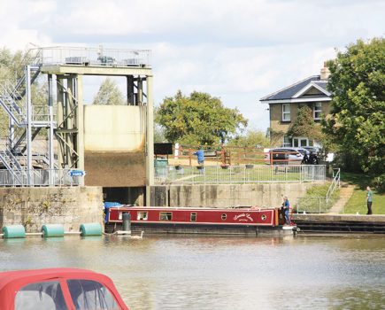
Today the canal ends rather abruptly at a dead end underneath a three-arch bridge. It’s a handy enough mooring for the town’s shops, pubs and railway station, but it really doesn’t look like the canal was meant to end there – and it didn’t. Two roughly parallel flights of locks (the Old Locks and New Locks) once led from here down to the Mersey (and later to the Manchester Ship Canal), completing the route from Manchester to Liverpool, but sadly the second of these was shut as recently as the 1960s – and the route blocked by the approaches to the then new Mersey Bridge.
Before you return to Preston Brook, tie up and take a walk down the footpath that follows the line of the Old Locks. There’s a group aiming to restore them and reopen them to navigation, opening up a useful connection via the Ship Canal to the River Weaver. One day it might also form part of a link across the Mersey to a restored Sankey Canal – showing that there are no hard feelings between the first two canals of the industrial canal building era…
Image(s) provided by:
Martin Ludgate