A 20-mile cruise on the narrow Peak Forest and Ashton canals will take you from the centre of Manchester to the fringes of the Peak District

We begin our journey at the western end of the Ashton-under-Lyne Canal (to give it its seldom-used full name) at Ducie Street Basin in central Manchester, but in all probability those boating it in this direction will have arrived from further afield.
They may have come from the south west, arriving via the Bridgewater coming up from the Runcorn direction (perhaps as part of a Cheshire Ring cruise); they may have arrived from the north west, reaching Manchester on the Bridgewater Canal’s Stretford and Leigh Branch which links to the Leeds & Liverpool Canal; or they may have arrived from the north east on the Rochdale Canal, crossing the Pennines from Yorkshire. And the reason I mention all these canals is because of the one feature they have in common, and in which they differ from the Ashton Canal. Like most northern canals they were all built for wide-beam boats of around 14ft wide, based on the local river craft from the pre-canal era; the Ashton, by contrast, was (at the time of its opening) the odd one out, having been built for 7ft beam narrowboats more common on the Midlands canals.
This may seem like an inconvenience and a piece of bad planning, but in 1792 when the Ashton’s first Act of Parliament was passed, the Rochdale Canal had yet to be authorised. The Ashton was to be a short (around six miles) isolated line of canal serving a local function carrying coal from around the Ashton-under-Lyne and (via a branch canal) Oldham areas to Manchester – so presumably there wasn’t seen to be any reason to make it wide-beam. And once the Ashton had been built narrow, so too were its connected waterways (with many of the same shareholders) the Peak Forest and Huddersfield canals, creating a small narrow system in a land of wide canals.

Beswick Locks begin the climb out of Manchester on the Ashton Canal
This change may not be immediately obvious as you leave the Rochdale Canal via a long and tunnel-like bridge, turn sharp left at a small basin which was once much larger and served the Ashton Canal’s various warehouses, pass through what has been regenerated in recent years as the Piccadilly Village development, and cross the substantial Store Street Aqueduct. But soon after that, the first of 18 narrow locks makes it clear that you’re on a canal built for narrowboats.
Yes, that’s right: 18 locks, on a main line that’s only a little over six miles long. In terms of locks per mile it’s one of our steepest waterways (albeit rather overshadowed by the 74 locks in 20 miles of the trans-Pennine Huddersfield Narrow Canal), and they start with the three Ancoats Locks. Surroundings are mixed, with some striking modern developments including the curious ‘Chips’ building – inspired by three French fries on a plate, apparently – as well as older industrial premises. An old arm on the left, reopened as a mooring basin, is one of many arms and branches which formerly linked the canal to the industries it served – including a couple of rather longer branches (see later) they once totalled more than double the length of the canal’s main line.
The modern regeneration schemes are left behind as the canal passes through industrial east Manchester, interrupted for a while by Sportcity, a former colliery site which boasts that it is now Europe’s largest concentration of sporting venues: site of the 2002 Commonwealth Games and including the National Cycling Centre and BMX indoor arena, the National Squash Centre, Manchester City’s football ground and the regional athletics stadium.

Descending the flight of nine Clayton Locks
Meanwhile the locks continue with the Beswick four, followed by the Clayton nine. The former coal mining has left its mark, with ground level subsidence leading to some wildly varying lock heights: lock 6 rises just 3ft 6in, while lock 10 is almost exactly four times as deep, with the biggest rise of any narrow lock in Britain at 13ft 10in.
Surroundings remain industrial, but there is plenty to see: look out for Clayton Junction, the start of one of the longer branches, the Stockport Arm which departed under a surviving towpath bridge between locks 10 and 11. It was only abandoned in the 1960s, and although the far end approaching Stockport has largely disappeared, the infilled line first couple of miles to Debdale survive as a footpath, and there is an active canal restoration group the Manchester & Stockport Canal Society. Look out also for the remains of the swingbridge (they were a feature of the canal and a couple have survived) which once crossed Lock 12 – and the useful pub by this lock.

The top two locks on the Ashton Canal used to be duplicated – you can see on the left in this picture where the second lock used to be
The final two Fairfield Locks were once busy enough to be duplicated, and the remains of the second chambers can still be seen. They bring us to the summit, and to another former junction. Here the Hollinwood Branch headed north, climbing eight locks to the edge of Oldham. Although it’s suffered since abandonment in the 1960s, it too is subject to restoration proposals by the Hollinwood Canal Society – and the first short section has been reopened as access to a new mooring basin.
If the 1960s seems surprisingly recent for canal branches still to have been closing down, bear in mind that the Ashton itself was under serious threat at the time, having been allowed to fall derelict (along with the lower Peak Forest from Dukinfield to Marple and the connecting length of the Rochdale through central Manchester) despite being officially still open. Stopping it from being abandoned and filled in was a major victory for the waterways revival campaign, while clearing it and reopening it to navigation involved a massive effort by volunteers. This included two ‘Big Dig’ major working parties attracting hundreds of supporters, ‘Operation Ashton’ in 1968 followed by ‘Ashtac’ four years later, which removed vast quantities of mud and rubbish from the canal.

Dukinfield Junction with the Peak Forest Canal leading off on the left
Both of these had a major impact on the final sections of canal that we are now following, but as the summit level heads eastwards past Droylsden, Audenshaw and Guide Bridge there’s no indication that it was ever anything other than a fully navigable (albeit heavily built-up) waterway. The canal accompanies a railway embankment, then veers away to run alongside the River Tame: look out for a glimpse through the undergrowth of Dukinfield Aqueduct as the canal approaches Dukinfield Junction.
It’s tempting to describe the junction, with its splendid towpath bridge, Portland Basin, and fine warehouse (rebuilt after a disastrous fire in the 1960s) as “where three canals meet” – but that’s not strictly accurate. Straight ahead does indeed lead to the Huddersfield Narrow Canal, but it’s still the Ashton for another half mile first before the two meet end-to-end at a small basin. This half mile includes ‘Asda Tunnel’, a length covered over during the 1980s to build a supermarket on top. I can’t help wondering if the tunnel will still bear that name if the supermarket chain ceases to be?
I was going to continue with “A sharp right at the junction turn takes us under the towpath bridge and into the Peak Forest Canal” – but that’s not strictly true either. The towpath bridge and the sturdy stone aqueduct just beyond which crosses the River Tame are also still part of the Ashton Canal, and the start of the Peak Forest is indicated by the ‘zero’ milestone by the far end of the aqueduct.
As we mentioned earlier the Peak Forest was built to narrow-beam dimensions to match the Ashton, and it opened in 1804 with its main purpose being to transport lime from the limestone quarries of the Peak District to serve the industries of Manchester and surrounding towns.

Old industrial buildings in Hyde
So we’re still on a narrow canal, and we’re still passing through largely built up and ex-industrial areas on the eastern fringes of Manchester, but I feel that the Peak Forest has a different atmosphere to it. I think it’s the way it winds a little as it follows the contour along the side of the Tame Valley, the resulting lack of locks (there aren’t any for almost eight miles), and the fact that the industry has retreated just a little way from the canal, allowing some more semblance of a rural waterway after the almost continuously urban Ashton.
There may be no locks, but not far from the junction we meet the first of a new navigation feature – a lift bridge. The meandering course leads southwards to Hyde, an industrial town with a couple of historic canalside warehouse buildings and a rare example of a pub with a canal-related name from the modern era: the Cheshire Ring. Although the idea of cruising rings is a modern concept that might not always find favour with all waterways enthusiasts, saving the 97-mile Cheshire Ring (the name was coined in 1965) was certainly an idea that caught the imagination and focused support for restoring and reopening these canals.

The short Woodley Tunnel, complete with towpath
Continuing south from Hyde we reach the first genuinely rural length so far, as the canal passes through Haughton Vale Nature Reserve before approaching Woodley, where we meet the first of two tunnels. Woodley Tunnel, the shorter at at 167 yards, has a towpath, but a couple of miles further on at the 308 yard Hyde Bank Tunnel towpath walkers will need to follow a series of paths over the top to rejoin the canal at the far end. The River Tame has left us but the canal is still running along a valley side, with the River Goyt below on our right. A third tunnel at Rose Hill has long since been opened out, but a narrow cutting shows where it once was, as we approach the canal’s two most impressive engineering works.
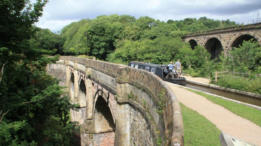
Marple Aqueduct, the highest in England, strides across the Goyt Valley on three arches almost 100ft above the river, in a splendid wooded setting (albeit slightly less so thanks to some thinning-out of vegetation which has served to provide a better view of the structure from paths leading down from the towpath) and paralleled by an even higher railway viaduct. This was the scene of another episode in the battle to save the canals, when a section of the outer face collapsed in 1962, leading to suggestions that demolishing the aqueduct and abandoning the canal would be a better use of money than funding repairs. Four years later it had not only been saved, but scheduled as an ancient monument.

Looking down the steep Marple Locks flight
There’s little gap between the aqueduct and the start of the canal’s second major feature: Marple Locks. Unlike the Ashton Canal with its subsidence-affected locks of various depth, Marple are a pretty even flight. All 16 chambers are the same depth within a few inches, and they’re all extremely deep. At around 13ft each they raise the canal an impressive 209ft in a mile, the locks constructed from massive stone blocks. It’s tempting to add “…and looking like they were built to last for ever”, but a couple of locks have unexpectedly needed complete chamber wall rebuilds in recent years after they showed signs of movement. Hopefully there won’t be too many more nasty surprises.
The locks begin on a wooded embankment (with a railway tunnel passing through it, although you wouldn’t know it from the canal), then continue climbing alongside a road running through the eastern fringe of Marple town, to end at a junction – and a convenient place to moor and visit the town. Here the Macclesfield Canal bears right through one of its distinctive ‘snake’ bridges carrying the towpath over and under the bridge, continuing the route of the Cheshire Ring southwards. Meanwhile the upper Peak Forest continues south eastwards as a dead-end, but one well worth a detour for its magnificent scenery on the fringes of the Peak District.

Passing the Swizzels sweets factory at New Mills
The canal hugs the valley side high above the River Goyt, clinging to the contour as it passes Strines and Disley. There are no more locks – the 16 at Marple have raised the canal to a level that will continue all the way to its terminus – but a handful of liftbridges and swingbridges provide some exercise. The course is almost entirely rural, and few busy roads come near – although for a mile or so from Disley to New Mills, the canal has the odd distinction of sharing its valley with three working railway lines.
New Mills is – you won’t be surprised to hear – a mill town. It’s also home to Swizzels sweet factory (as you can tell from the scent in the air, as well as the canalside building with its traditional tall mill chimney), a useful stopping point for boaters with a marina and shops, and also worth a visit for the Torrs riverside park and spectacular Millennium Walkway above the River Goyt.

Opening bridges are a feature of the Peak Forest Canal

On the final scenic length near the Whaley Bridge terminus
The final length of the canal is no less attractive as the valley narrows and the river climbs up towards the canal’s level. Passing Furness Vale, we reach a junction: straight on for Whaley Bridge, or left for Bugsworth. For many years the only option was to continue ahead, to reach the terminus basin with its transhipment warehouse (restored in recent years as a community space with all manner of events and activities taking place) and moorings to visit the attractive old town.

Entrance to the restored former industrial complex at Bugsworth Basin
The other branch, to Bugsworth Basin, was originally seen as more important than the Whaley Bridge line as it provided the main connection to the limestone quarries and developed as a major inland port and interchange complex. However it fell into disuse in the 1920s with the ending of the lime traffic – but now, thanks to a half-century of work by Bugsworth Basin Heritage Trust and its predecessors, the entire complex has been restored and makes a fine terminus and end to our journey from the heart of Manchester to the fringe of the Peak District.
Image(s) provided by:
Martin Ludgate