With the Cheshire Plain on one side and the Peak District hills on the other, the Macclesfield provides glorious views, splendid old mills, and a rhyme about a bear…

I remember reading in a waterways guidebook a long time ago a suggestion that it was not uncommon to find frustrated boaters cruising up and down the short length of the Trent & Mersey Canal in Kidsgrove between the north portal of Harecastle Tunnel and the lock that marks the end of the summit level, looking in vain for the Macclesfield Canal branching off northwards.
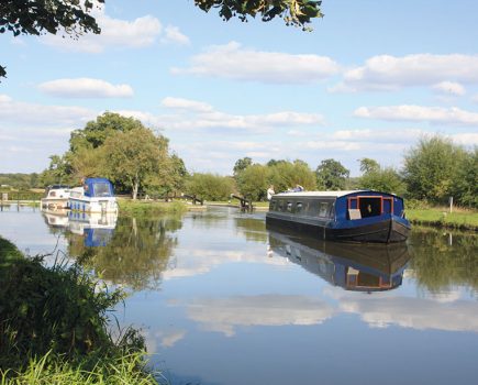
I’ll confess that I was a little sceptical, but it’s true that in what might seem a rather back-to-front piece of canal engineering, the builders of the Macclesfield Canal chose to branch off not northwards but southwards (and hence these hapless boaters would have been looking on the wrong side of the canal for the junction). It passes under a towpath bridge before immediately swinging round to the right. The two canals then run parallel, the T&M passing through the first two locks of the long descent into the Cheshire Plain, before the Macc takes another sharp right turn, crosses the Trent & Mersey on the sturdy (rather than particularly elegant) Pool Lock Aqueduct and finally heads off in the general direction of Macclesfield.

Actually when I mentioned the builders of the Macclesfield Canal above, I was being a tiny bit economical with the truth, as this first length wasn’t built by the Macclesfield Canal Company at all. The T&M company chose to build the first section themselves (just as they did at their junction with the Shropshire Union in Middlewich), only handing over to the Macclesfield after a mile and a half at Kent Green. You can actually see the difference.

The Macc is famed for its fine stone structures (plus the odd iron aqueduct) to engineer Thomas Telford’s design; but on this length the main building material is brick.
The official start of the Macc is marked by a shallow water-regulating stop-lock at Hall Green, one of the handful of such relics of the jealous guarding of precious water supplies which still survive as working locks. And it boasts a few unusual features, in addition to its shallow rise of just a few inches. The chamber is double-length, as it was once two locks end-to-end (the gates faced opposite ways to allow for a change of level in either direction); in reverse of the usual arrangement it has a single bottom gate but double top ones; and it’s accompanied by a lock cottage for each company (one in brick, one in stone, naturally).

We are now on the 26¼ miles of the Macclesfield ‘proper’ (its miles are marked out in a fine set of stone markers, the missing ones having been replaced by the Macclesfield Canal Society) which strikes off northwards past Scholar Green, site of legendary working boatmen’s pub the Bird in Hand, sadly long closed. Soon we get to experience some of the canal’s characteristic features. The splendid stone bridges have already been mentioned; while it’s clear from the cuttings, embankments and straight course that this canal is a relative newcomer, opened in 1831 to fill a gap in the system and give the mill towns of Macclesfield and Congleton a link to the outside world. Another feature used to be swingbridges: almost all have now been removed or replaced with fixed spans, but it’s easy to spot where they used to be.

Ramsdell Hall makes its presence felt: the lawn of the fine Georgian house runs down to a length of canal which was built wider and fitted with a long length of ornamental railings (restored in recent years) to improve the view for the hall’s owners. Also built for similar reasons was Mow Cop Castle, a folly the tops the hill to our right, constructed as a summer house, and to provide a romantic ruin on the horizon for the residents of the nearby Rode Hall. And a third local manor house is the most famous of them all: Little Moreton Hall.
Little Moreton Hall is a 16th century moated black and white timber-framed manor house with a labyrinth-like interior. Its most striking feature is its Long Gallery running along the top floor (whose weight has caused the building to sag over the years). The house and its re-created Tudor garden are owned by the National Trust and open from April to December every year.

Amid the countryside and homes of the wealthy, you might be surprised to find that this was once an industrial area. But for the industrial archaeologist there are traces of numerous mines, quarries, brickworks and the horse-tramways that connected them.

The canal continues northwards, the high ridge of hills on the right continuing from Mow Cop to Congleton Edge, while on our left the land falls away gently to the Cheshire Plain, giving fine views right across to the Welsh hills on a clear day.
You could easily miss the first of another Macclesfield Canal feature – aqueducts – which carries the canal (with no narrowing of the channel) over a tiny country lane near Astbury.

Approaching Congleton you’ll come across yet another speciality of the Macc: ‘snake bridges’. These beautifully built stone turnover bridges take the towpath from one side of the canal to the other, the path snaking over and under the bridge in a graceful curve (and from a practical point of view, avoiding the horse towrope snagging on anything).

Congleton’s town centre is a mile to the west: walk into town from Dog Lane Aqueduct (a fine cast iron structure over a main road) or from the railway station. A handy market town with plenty of pubs and shops, Congleton has a rather odd claim to fame…
Congleton rare, Congleton rare,

Sold the bible to buy a bear
…which commemorates the town responding to the untimely death of the bear-baiting bear on the eve of the annual Wakes Week some 400 years ago by raiding a fund set aside for a new town bible. Of the various local concerns which use the town’s nickname ‘Beartown’ today, one likely to be of interest to some boaters is the Beartown Brewery.

Leaving the town in a deep cutting, the canal’s course which has up to now been mainly straight, takes a much less direct route as it contends with more hilly country. The Dane-in-Shaw brook is crossed on a high embankment, the River Dane on an impressive single-arch aqueduct. Away to the west, a high 20-arch viaduct carries the railway whose 1849 opening meant that the canal’s prosperity was short-lived (in fact it had already sold out to a rival railway company by then), while the distinctive shape of the hill to the east called The Cloud is due in part to the quarry which provided the stone for the viaduct.

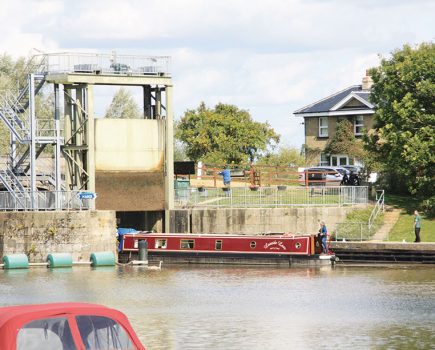
Other than the stop-lock our route has been level so far, but that changes at Bosley, where all 12 of the canal’s locks are concentrated in a single flight. Their features include stone-built chambers (from the same quarry on The Cloud), double gates at both ends (unusual for narrow locks), water-saving sideponds (no longer in use), and blocking pins – metal spikes by the head of the locks which (used in combination with a pulley block on the boat) provided a mechanical advantage when starting a heavy horse-drawn boat. For those not interested in such waterways trivia, the locks are also in a splendid setting with glorious views of the surrounding hills and countryside.
We’re now on what was (until the reopening of the trans-Pennine canals) the highest navigable level on the network – and it’s a long level too, stretching for over 20 miles in combination with the upper Peak Forest Canal. The hills come closer to the canal on the east side, as it runs along the very edge of the Peak District.
Oak Grove has a handy canalside pub, accompanied by a rarity today of a working swingbridge. It carries a minor road, and is electrically operated with a CRT key. Not far beyond is the sole survivor of the Macc’s traditional hand-operated swingbridges, carrying a public footpath.
At Sutton, where the canal crosses a road on a high embankment and aqueduct, there’s a link to James Brindley. The man who later became the most famous of our canal engineers served his apprenticeship as a millwright in a building just 100 yards east of the aqueduct, and marked with a plaque. But that was back in the 1730s: what an odd coincidence that a canal should be built so close to it almost a century later.
The approach to Macclesfield is marked by an impressively deep cutting, stone lined on the higher east bank, whose many stone buttresses (some quite recently built) bear witness to the problems that it has caused over the years.
What bears are to Congleton, silk is to Macclesfield. Not only does the town’s former mainstay industry feature in the names of everything from a radio station to a brass band, but four of its silk mills survived long enough to be preserved as museums (see inset). The canal runs high above the town, past the former Hovis mill by the town basin (now a marina and boatyard), with the closest access to Macclesfield’s shops and other facilities from Buxton Road Bridge 37.
The Hovis mill is just a foretaste for some truly impressive waterside textile mill buildings at Bollington, which the canal reaches after a short rural interlude. First comes the Adelphi Mill, now used for offices and light industry, followed by the Clarence Mill, which has converted to a mixture of residential and business use – including Canalside Community Radio. Between them the canal crosses the huge Bollington Embankment, pierced by a main road aqueduct, and a source of problems to the canal’s builders when it collapsed while part-complete.
A long, entirely rural length follows as the canal continues to skirt the edge of the hills, with the villages of Adlington and Poynton some distance away to the west. It’s kept company by the former Macclesfield to Marple railway line, now converted to a footpath / cycle trail. Not far from the canal at Higher Poynton is the Anson Engine Museum (see inset).
The only settlement of any size on this northern length of the canal is High Lane, home to the North Cheshire Cruising Club (one of the earliest canal-based clubs) which is housed in an arm of the canal. This arm, and the shorter arm at Higher Poynton which today houses Braidbar boatbuilders, are reminders that the countryside we’re passing through was once another industrial area. It seems unlikely today, but the East Cheshire coal industry once boasted more pits per square mile than almost anywhere else in Britain – and the arms were built to link the collieries to the canal. Another survival from those times is a series of flat-deck bridges in place of the traditional stone arches – this was so that they could easily be raised to combat subsidence.
A final two miles of gently meandering route leads to Marple, where the mighty Goyt Mill building heralds its arrival in the town. A pair of ‘snake’ bridges take the towpath briefly to the right-hand side (as in Congleton and Macclesfield, this was to keep the path on the opposite side of the canal from the town wharf, keeping passing trade clear of the wharf – and presumably helping to stop pilferage.) There are decent moorings here, pubs nearby, and Marple’s shops are a short walk from Bridge 2.
Just before the second towpath bridge, and adjacent to the wharf’s surviving stone-built warehouse, is a gateless former stop lock. It was built here to keep the waters of the Macc separate from those of the Peak Forest Canal, which it meets at a T-junction just beyond the bridge – and which we’ll be exploring next month.
Image(s) provided by:
Martin Ludgate