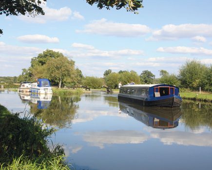
The Great Ouse systsem combines an attractive upper river navigation; a typical straight, wide Fenland waterway; and a whole series of tributaries, all with their own character

Look around you at Denver Sluice, the tidal limit of the Great Ouse where we begin this month’s cruise guide, and it’s hard not to come to the conclusion that whoever thought of giving the state capital of Colorado the same name was having a joke. While the American Denver might take pride in its nickname of ‘Mile High City’, at the great watery junction near Downham Market, all of the waterways and most of the surrounding land are close to or even below sea level. The flat fenland landscape stretches away into the distance, and as we leave Denver behind and head southwards on the non-tidal Great Ouse it’s obvious that what we’re cruising on is more of an artificial drainage channel than a natural river – and indeed, the original course of the Great Ouse ran further to the west.
The long reaches of straight, wide, deep channel with high banks might not provide the most scenic or interesting of cruising. But what they do provide is a link between a whole series of attractive navigable tributaries which are well worth exploring – and the first one branches off within a mile or so of Denver.
The Wissey is a personal favourite and probably the most ‘river-like’ of the tributaries. As soon as the Great Ouse is left behind, the river takes on a typical meandering course – even though initially it is still constrained between high banks. Soon on the left you’ll see signs indicating ‘GOBA Moorings’ – the Great Ouse Boating Association provides many of these simple visitor moorings for members, often in quiet out-of-the-way places, on a river system that isn’t particularly well-supplied with moorings. It’s well worth the modest subscription fee to join, and your money will go to help create more of these moorings. Incidentally it may simply be that 2018 was a bumper year, but we found all the moorings on the Great Ouse tributaries were excellent sources of hedgerow fruit in late summer.

Hilgay (as its name might suggest) is a village on a slight hill, indicating that we’re leaving the flattest part of the fenlands behind. Its useful shops and pub are worth stopping for, as there isn’t a lot else on the Wissey. There follows a curious length where the navigation passes through a series of small lakes (bear left when heading up river to avoid a dead-end), and skirts a sugar works, before the winding channel continues towards Stoke Ferry.
Just to remind you it isn’t an entirely natural river, the Wissey then crosses a concrete aqueduct, passes through a large sluice gate, and then meets a junction with a channel leading off sharp left through another sluice. This is the intersection with the Cut-off Channel, an unnavigable drainage waterway built to take flood water from the Lark, Wissey and Little Ouse and carry it down to the Great Ouse Relief Channel at Denver and into the tideway beyond.
Stoke Ferry and Whittington villages stand either side of the river: sadly neither has a pub any more, but there are village shops and takeaways. Not far upstream, where a stream joins the river, there is room to turn a full-length boat – and this forms the effective head of navigation for most visitors, although some craft have been known to get some distance further, at the risk of having to reverse out if they are too long to turn.

Back on the Great Ouse, another five miles of wide and gently meandering river lead to Brandon Creek, where a pub marks the entrance to the second tributary, the Little Ouse. Although straighter and more fen-like than the Wissey for the first few miles, in its upper reaches it begins to wind, the high banks disappear to reveal wider views, and the approach to Brandon is very attractive. Sadly the new lock built some years ago half a mile before the town is too short for many boats, but it’s a pleasant walk along a riverside path. For craft that fit the lock, there are visitor moorings by the bridge, and it may (shallows and fallen branches permitting) be possible to navigate another two miles to Santon Downham in Thetford Forest. One day it may be possible to cruise right through to Thetford.
Returning once again to the Great Ouse, another four miles of straight channel lead to Littleport, the first place of any size on the main river since leaving Denver, and a useful stopping point. The next tributary is the River Lark, whose ten miles also begin as a typical straight and high-sided channel which passes the Prickwillow Pumping Station Museum, but is also transformed for its last mile or two into an attractive small river winding its way to West Row, where a waterside pub stands next to a full-length winding hole. Once again it may be possible to continue a little way further (it used to carry on right through to Bury St Edmunds), but the channel soon shallows, there is nowhere to turn, and a former staunch (a primitive form of lock consisting of a single set of gates) a mile beyond West Row prevents further progress anyway.
Back on the Great Ouse we are now on the approach to Ely, with the cathedral visible from some distance way. Ely has a fine waterfront, there are boatyards and boater facilities, and visitor moorings to explore the historic city.

Three miles beyond at Pope’s Corner the river divides, and this time the Cam, although nominally the tributary, is actually the larger of the two channels. Another three miles upstream, the Cam divides again, with the left-hand channel leading to Upware Lock. If your boat is short enough, this gives access to a set of three short waterways known as the Lodes. Possibly dating back to Roman days, these narrow channels served villages on the edge of the Fenlands. Burwell Lode and Reach Lode are navigable as far as the villages of those names, while Wicken Lode can be cruised for the first mile to a junction where it is possible to turn, and to walk to the Wicken Fen Nature Reserve.
Meanwhile the Cam, like the other Great Ouse tributaries, makes a transformation from Fenland waterway to more natural river as it passes through two locks on the approach to Cambridge. The attractive entry to the famous university city is accompanied by riverside meadows and commons (you’ll see cattle wandering around surprisingly close to the city centre) and there are moorings near Jesus Lock. This lock and the final length past the ‘backs’ into the city are the preserve of punts during the summer season, but between October and March it is possible to book your passage and cruise to the Mill Pond and back.
Returning to Pope’s Corner we enter a length of the Great Ouse known as the Old West River. A quiet, narrow, winding channel through a rather empty landscape, it was only actually the main channel of the river for a relatively short time (from when the river shifted from its original more westerly route until the New Bedford River was built) and its name derives from the fact that it was originally a tributary flowing westward. Look out for the Stretham steam pumping station, now preserved and open on certain days.

At the keeper-operated Hermitage Lock you may be surprised to find yourself locking upwards into tidal water. The explanation is that the artificial New Bedford River, which takes the main flow of the Great Ouse these days (and is navigable, providing a useful shortcut, albeit a dead straight and not terribly interesting one, to Denver) enters just above the lock.
Be wary of mooring on this tidal length which passes through Earith (where there is a useful pub with pontoon moorings) to end at Brownshill Staunch. Here, the lock has guillotine gates at both ends, is a rare example of a boater-operated tidal lock, and stands in a rather bleak landscape. But as with all its tributaries, the Great Ouse itself now undergoes a transformation, becoming a much more typical river navigation for the upstream journey to Bedford with meandering reaches, locks, mills and waterside towns. The first of these towns is St Ives, with its fine waterside and one of only a handful of bridges in the country with a chapel built part way along it – and the only such bridge that you can navigate under.
Skirting the historic Hemingford Meadow and passing Hemingford’s waterside church, the river climbs gently through occasional locks to pass between Huntingdon and Godmanchester.

You will notice that Great Ouse locks often feature a guillotine gate at one end, and this (as on the River Nene) is a clue to the upper river’s 20th century history. The navigation (other than Denver Sluice and the long level through Ely) having fallen into dereliction around the late turn of the century (there were legal battles in which the local authorities opposed the navigation owner’s attempts to charge tolls for the locks, but then took him to court when he tried to close them!) a drainage board was established which (again, like the Nene) in the 1930s began to rebuild the locks with guillotine gates so that they could be used as sluices for flood control – but also for navigation. With leisure traffic increasing, after the Second World War the Great Ouse Restoration Society was formed to support the continuation of this work, which was finally completed in 1978.
You’ll also notice that a number of the locks feature an extension on one side, the chamber, added to increase the number of boats that can pass at once. And do watch out for one or two places where the lock approach channels aren’t obvious as the river splits – there are signs, but they can become hidden in the undergrowth.
The East Coast Main Line railway makes its presence felt as the river turns southwards past Offord Cluny and Little Paxton to St Neots, another fine waterside town. Below Roxton Lock where the river turns westwards againi, look out for a small river joining from the south: this is the River Ivel, which once linked Shefford and Biggleswade to the Great Ouse. It’s possible to follow much of it on foot, and there are remains of old locks to be found.

The upper reaches of the Great Ouse are much quieter than the lower lengths, and you’re unlikely to see many boats as you cruise past Great Barford and Willington. The locks on this length were the last to be rebuilt (Castle Mills was the final lock, completed in 1978) and are modern concrete chambers with conventional mitre gates and accompanying weir sluices. By contrast, if you look out on your left above Barford you can spot the remains of one of the old locks dating from before the 20th century reconstruction; that in turn is positively modern compared to the 17-arch Mediaeval Barford Bridge.
A bridge carrying the A421 bypass heralds the approach to Bedford, and for the last few locks leading into the town the navigation reverts to guillotine gates again. A huge pyramid appearing rather startlingly on your left is actually a swimming pool and leisure centre. Priory Marina provides for boaters’ needs, but the river through the town is more the preserve of rowers. The final lock is approached by a sharp right turn, followed by an equally sharp left into the reach running through the town centre. Past the town bridge there are visitor moorings to the right (take it carefully, there are shallows both upstream and downstream).
But that isn’t quite the end of the journey. Subject to headroom (there’s a low railway bridge), draught and water levels, boats can reach at least two miles further, possibly as far as Kempston Weir. We’ve come a long way from the Fenlands, and for those boats which are visiting from the canal system, even further from the Grand Union Northampton Arm. And yet the GU main line is barely more than ten miles away…

That’s the thinking behind the Bedford & Milton Keynes Waterway Trust’s plan to build a link between the two, create a new ring, help make a broad-beam route from the southern to the northern waterways, and bring more boats on the quiet upper Great Ouse. In the meantime this is where we must turn and return to the Fenlands.


Image(s) provided by:
Martin Ludgate