Two narrow canals, one broad canal and one river make up the first part of this varied Midlands circuit, as we cruise from Hanbury via Droitwich and Stourport to Stourton.

Let’s start this guide to the Stourport Ring by attempting to decide what we mean by ‘Stourport Ring’ – because there are several options which have changed a little over the years as canals have reopened…
At its simplest, it’s the cruising circuit consisting of the River Severn from Worcester to Storuport, then the Staffordshire & Worcestershire canal to Autherley Junction near Wolverhampton, the Main Line of the Birmingham Canal Navigations to Birmingham, and finally the Worcester & Birmingham Canal back to the start at Worcester. But since the restoration of the Stourbridge Canal in the late 1960s (probably before the name ‘Stourport Ring’ had even been coined), a slightly shorter alternative route has been available, via the Stourbridge Canal from Stourton Junction to Delph and the Dudley Canal from there to Dudley Port on the BCN Main Line. Fast forward to 2011, and with the opening of the Droitwich Barge Canal and Droitwich Junction Canals another option, slightly shorter again, became available: going via Droitwich instead of Worcester.

10 canalside pubs on the Stourport Ring
And that’s the option we’ll take in this two-part article, taking in no fewer than eight different waterways (arguably nine or ten – as we’ll explain in Part Two) in a varied circuit of the West Midlands’ towns and countryside adding up to around 70 miles, but with 104 locks as the route climbs into and out of the Severn Valley.
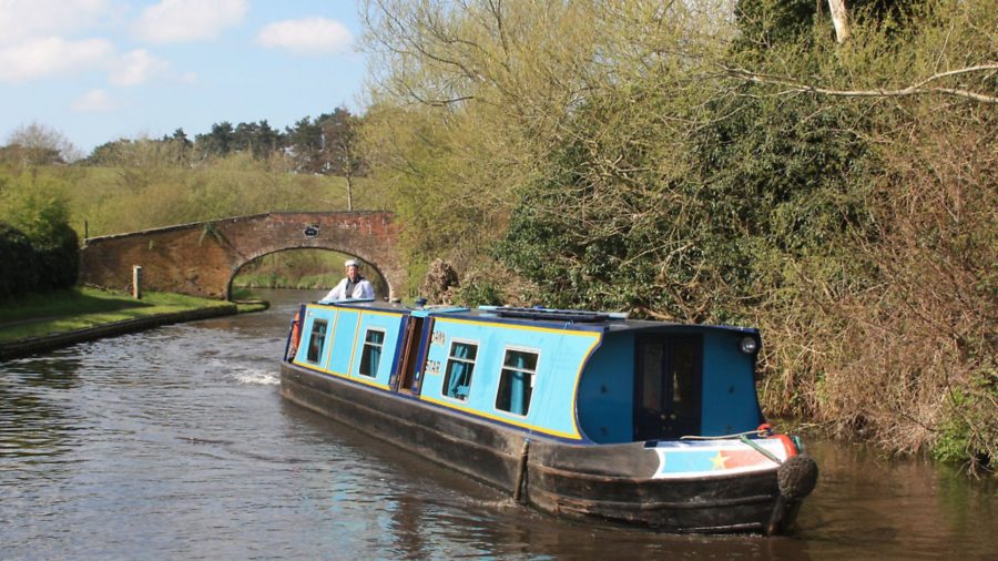
We’ll start at Hanbury Junction, where the Droitwich and Worcester & Birmingham Canals meet – there’s a handy boatyard, and for those wanting to explore the ring on hire craft there are a couple of bases not far away in either direction on the W&B.

We begin by heading west from the junction (it’s a tight turn if you’re approaching from Worcester direction) on the narrow-beam Droitwich Junction Canal. A relative latecomer, it was only opened in 1854: it closed a gap of one and three quarter miles between the Droitwich Barge Canal and the Worcester & Birmingham, at a time when competition from the railways was starting to have an impact on the canals’ trade in coal and salt. After a working life of little over 70 years, it went out of use in the late 1920s and was officially closed in 1939 – but thanks to a campaign begun by Droitwich Canals Trust in the 1970s, both of the Droitwich canals were restored and the through route reopened in 2011.
As you arrive at the three Hanbury Locks, you can appreciate that they were ‘state of the art’ in the 1850s, with deep chambers built from railway-era blue engineering bricks, and water-saving sideponds. I would appreciate it if boaters treat the locks with care, as I was one of the volunteers who helped restore them from dereliction…

Passing a marina entrance below the third lock, the canal takes a diversion, with three new locks (including a staircase pair) which were built in the latter stages of restoration (they’re 21st century ‘state of the art’ with concrete walls) replacing the original ones. Eight years on from the reopening, trees and vegetation have grown up around the canal and it looks a lot less ‘raw’. The locks lower the canal to the right level for a very tight squeeze through a concrete culvert under the M5 motorway – pay attention to the height gauge (water levels can vary as a small stream feeds the canal), and remove everything from your cabin roof.
A fourth and final new lock leads to a junction with the River Salwarpe: it’s little more than a stream, but still capable of causing problems after heavy rain, so keep an eye on water levels, and don’t moor overnight on this section. There’s little sign now of where the original route rejoins on the way into Droitwich, before the canal leaves the Salwarpe on the approach to the Barge Lock.

This lock marks the end of the Droitwich Junction Canal and leads to the start of the Droitwich Barge Canal. As its name implies, unlike the narrow locks built for 7ft beam narrowboats that we’ve seen so far, this lock was built to ‘barge’ width (around 14ft) to enable Severn trows (sailing barges) from the Barge Canal to access wharves on the Salwarpe. Its function is as a water control lock to keep river and canal separate, and there’s rarely more than a few inches of fall.
Leaving the lock, we’re now on the much earlier Barge Canal, opened in 1771 to link the salt town of Droitwich to the River Severn. We’re also near the centre of the town, in the attractive Vines Park which features no fewer than four swingbridges (three of them in use) and handy visitor moorings (including a basin with pontoon moorings accessible by CRT key) for the town’s shops and other facilities. You’ll see signs of the former salt industry in the form of a High Street whose buildings have clearly suffered from subsidence, and a church tower visible from the canal with a distinct lean (if not quite on the Pisa scale!)

Passing the canal’s only waterside pub the Railway (which sustained many of us volunteers in the evenings during the restoration work) the canal leaves the town centre via two railway bridges. For railway enthusiasts these are notable for the adjacent signal box and array of old semaphore signals still in use; for boaters (especially those in larger craft) it’s perhaps of more interest that the second bridge is an ‘Armco’ culvert inserted in the early years of restoration which prevents wider boats from reaching Droitwich.
Housing estates accompany the canal on the left, and sports fields on the right, as it gradually leaves Droitwich behind. The A38 bypass bridge marks the end of the town, and the canal is left to itself as it follows the quiet Salwarpe valley down to the Severn.

The typical gentle meanderings of an early canal are interrupted by a short but deep cutting at Salwarpe village, then a mile further on the three-mile pound from Droitwich comes to an end, where a traditional lock cottage stands alongside the first of the five wide-beam Ladywood Locks. These mark the site of the ‘Big Dig’ major volunteer working party which launched the restoration in the 1970s, but today their gentle descent blends in with the scenery.
Another two miles of following the extravagant meanderings of the Salwarpe are punctuated by a further lock and by Linacre Bridge – an example of an original 1770s bridge, where you may be able to make out the scrape marks from the lowered masts of sailing trows which passed under it in the early days. At Hawford, modern life makes itself felt in the form of the A449 dual carriageway, whose wide embankment crosses the canal at an oblique angle and formed a serious obstacle to reopening of the canal. The solution was a long, tunnel-like concrete navigable culvert: it’s not pretty, but it does the job.

The final length of canal descends through a final pair of locks to reach the Severn: it’s a sharp right turn into the current to continue on the Stourport Ring, but the river’s wide enough not to cause any problems.
This is a quiet length of the Severn, with little sign of habitation for a couple of miles to Holt. Here a Thomas Telford bridge spans the river, with a pub on each bank, followed closely by the approach to Holt Lock. Like all locks on the river it’s powered and keeper operated. Steep wooded banks and occasional sandstone outcrops flank the river as it continues north past two isolated settlements with waterside pubs and the occasional riverside caravan site.

Lincombe Lock marks the beginning of the approach to Stourport, with signs of the former oil tanker trade on the right followed by a view of Stourport Bridge ahead. This is where we leave the Severn to join our fourth waterway, the Staffordshire & Worcestershire Canal – another early canal, opened in 1772.
Local legend has it that when canal engineer James Brindley was planning the Staffs & Worcs Canal (which formed the River Severn arm of his ‘Grand Cross’ of canals linking the Trent, Mersey, Thames and Severn) he hoped to join it to the Severn at the existing river port of Bewdley, a few miles further up-river. However the citizens of Bewdley told him to take his “stinking ditch” elsewhere – so he did, creating the great new inland port of Stourport where his canal met the river. Bewdley’s folk duly got their comeuppance as the new town prospered while theirs declined. It’s a great story, but the geography suggests that Stourport actually made much more sense as a junction, being close to the mouth of the little River Stour whose valley the canal follows for its first 12 miles.

Whatever the truth of the story, Stourport is a unique example of a canal town, with a complex of five basins on two levels connected to each other and to the river by wide and narrow locks (narrowboats should normally use the narrow locks, which comprise two staircase pairs), surrounded by fine buildings including the Clock Warehouse and Tontine Hotel. Today it’s also a great leisure boating centre with all facilities available, and as well as a good place to stock up on provisions as it’s the first settlement of any size since Droitwich.
Leaving the basins via the deep York Street Lock (narrow beam, like the rest of the canal), the canal winds its way through the town before leaving it behind and following the attractive Stour valley. An arch on the right marks where an arm used to link to the River Stour to serve a nearby ironworks.

By Falling Sands Lock you will see the red sandstone outcrops which are a feature of the canal as it climbs the Stour valley; shortly afterwards, look out for the steam trains on the Severn Valley Railway (see inset) crossing the canal on a high viaduct.
The carpet factories which made Kidderminster famous used to line the canal on both sides, the tall red-brick buildings making for a canyon-like approach to the town centre. Today many have disappeared or found new uses, and while this area has gained convenient canalside shopping, it has lost some of its atmosphere. A deep lock raises the canal to cross a small aqueduct over the Stour near the town centre, overlooked by Kidderminster’s Parish Church.

The town’s housing estates are left behind as the canal continues generally northwards, winding left and right to follow the twisting valley with its wooded hillsides and sandstone cliffs. The villages of Wolverley, Cookley (situated directly above the diminutive 65-yard Cookley Tunnel) and Caunsall provide pubs for thirsty boaters, while locks every couple of miles continue the gentle climb from the Severn towards the high ground of the West Midlands; look out for the curious cellar or cavern cut into the rock alongside Debdale Lock.
Kinver is the first sizeable place since Kidderminster, with a selection of useful shops and several pubs, not to mention its cave dwellings (see inset). It’s followed by another quiet length following the Stour valley, including an even shorter tunnel at Dunsley, barely the length of a boat.

Not far beyond the tunnel is Stourton Junction, where our route takes a right turn onto the Stourbridge Canal, and where we will end this first part of our Stourport Ring cruise, leaving us a further four waterways (or possibly five or six) to cover in the second part.
Incidentally just before the junction, the canal passes the curiously named Stewponey Lock. This recalls a now closed 1930s pub of the same name, which carried on the name of its 18th century predecessor; that in turn is said to have taken its name from a corruption of ‘Estepona’, the town in Spain where the wife of the original pub landlord had come from (the landlord having been quartered there).
Personally I’m not sure it’s that much more convincing than the story about Brindley’s stinking ditch…
Image(s) provided by:
Martin Ludgate


