It wasn’t just in England that canal mania took hold – a link between New York and the Great Lakes goes back to the early 19th century. In part one, Jane and Ian Ainsworth start their cruise on the Erie, get to grips with American locks and face some hideous weather

The Erie Canal has long held a fascination for me, perhaps because of an old song I learned in my schooldays that conjured an image of horses and mules pulling working boats for long hours. So, after journeying around America’s Great Loop from Florida up the intra-coastal waterway to Albany, New York, I was excited to finally be in sight of it.

The waterway was first proposed in 1807, some years after the canal system had brought prosperity to the industrialised areas of England. The benefits of an East-West waterway linking Buffalo on Lake Erie, with Albany on the Hudson River and thus New York, were obvious. The Mohawk Valley, separating the Adirondack Mountains to the north and the Catskills to the south, was chosen for the route.
The original canal opened in 1825 for use by horse- and mule-drawn barges. As a result of its construction, Buffalo grew from a population of 200 settlers in 1820 to more than 18,000 in 1840, and New York City became the Atlantic home port for the Midwest.

Since the early days, there have been many modifications in both the route and depth of the canal. By the 1890s, canal traffic was declining, as in England, because of competition from railways and better roads. In 1905, work began on the New York State Barge Canal, which combined the old Erie Canal with parts of the Mohawk River. The Barge Canal was large enough to allow the use of motorised vessels, and the mules, horses and towpaths became history.
The canal is now part of both the New York State Canal System, which manages it, and the Erie Canalway National Heritage Corridor to recognise its influence on the commercial development of North America and its importance as a work of civil engineering and construction. Bruce Springsteen sang a haunting rendition of the Erie Canal song written in 1905 by Thomas S. Allen to commemorate the old days.

It was with some anticipation that we left Coeyman’s Landing, ten miles south of Albany on the Hudson River, to start our journey through the Erie and on to the Great Lakes and Canada.
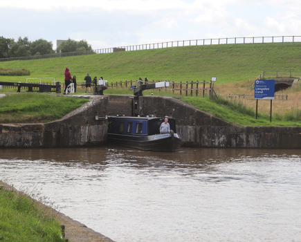
We felt slightly apprehensive about the locks. We were au fait with locks on English canals, and had travelled up the Thames from Limehouse Basin to Oxford, but American locks were an unknown quantity.
The guide to the New York State Canal System afforded some insight – pictograms showed the crew attached to long ropes dangling deep down into the bowels of the lock. How hard would it be to hang on to the rope, if the lock filled quickly causing turbulence and strong currents, or there were strong winds?

Then there was the question of etiquette. The guide stated clearly that it was not part of the lock-keeper’s job description to assist boaters. Presumably they would just look on sardonically in the face of boaters’ ineptitude.
In fact, the lock-keepers turned out to be unfailingly efficient and friendly, and it proved not too difficult to grab the long dangling rope with the boat hook, but we found out for ourselves that the fenders need to be much higher when you’re going into the locks than when you’re docking.
At Waterford, where the Erie starts and follows the Mohawk River, sometimes alongside and sometimes part of, there’s a flight of locks as the canal rises steeply above the Hudson Valley. The flight is said to be the largest in America, but it didn’t really compare with Foxton Locks or the Tardebigge flight. They were on a much grander scale, though, and the dark blue and gold livery lent an attractive cohesion to the New York State Canal System, which is perhaps lacking in the UK’s Canal & River Trust.

Where the canal has been incorporated into the Mohawk River, there are impressive weirs and dams beside the locks, and near to Lock 8, you can see the ruins of Lock 23 on the old Erie. This lock was once an important unloading point for the town of Schenectady, but it was abandoned when the Barge Canal was opened in 1918.

We stayed a couple of nights at Canajoharie. Although little more than a village, it has many old buildings and an impressive public library and art gallery, built by local industrialist, Bartlett Arkell, to house his collection of copies of European masterpieces and original American art, including works by Winslow Homer, Childe Hassam and John Singer Sargent.
Mr Arkell was a marketing visionary – when he founded the Imperial Packing Company in the 1890s, he thought a healthy-sounding name would appeal more to his customers so renamed it Beech-nut, as it expanded into the packing of meat and other produce. He was fascinated by circuses and marketed his products by having model circuses tour the country, with Beech-nut girls in fancy dress and aprons handing out samples of his products to awe-struck children. The gallery includes a display of the model circuses and photographs of Beech-nut marketing events. He was a benevolent employer and his workers enjoyed generous holidays and a comfortable lounge for their breaks, compelte with a grand piano.

Our next stop was Little Falls, but between there and Canajoharie was the biggest lock on the Erie – Lock 17, with a lift of 40ft. We ended up sharing it with a $3 million boat being transported to its new owner on Lake Michigan, but the lock overshadowed both us and our neighbour.
The landscape became more hilly as we approached Ilion, where we arranged to leave the boat for a fortnight while we visited our family in Washington DC. Don Sterling, the dockmaster at Ilion, very kindly took us to the station at Utica, ten miles away, to get our train at 6.30am. We were in plenty of time to admire the station’s splendid architecture.
On our return, we decided to stay a couple of days in Ilion to go to an evening open air concert in the town plaza and have a day exploring the tree-covered mountains and lakes of the Adirondacks. We climbed to the top of Pinnacle Watch Hill.

We had nearly reached the summit of the canal – the stretch between Locks 20 and 21 marks the highest point, so from 21 onwards, we were descending rather than ascending in the locks. This marked a point on our westward progress.


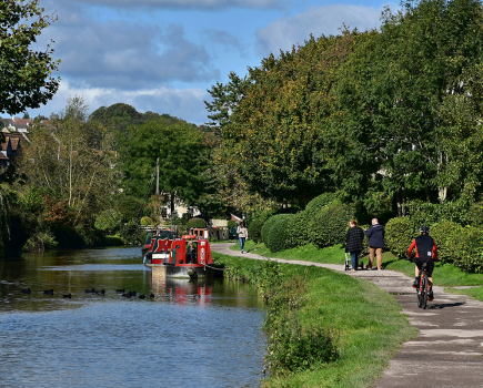
So far there had been few other boats on the canal, although we had seen several working boats bearing the New York State Canal System livery. But, as we approached the wide expanse of Oneida Lake, 20 miles long and five miles wide, there were several marinas and lots of small craft out on the water. The lake crossing was a welcome change after the enclosed feeling of the canal.


It shouldn’t be assumed the weather in America would really be any better than the weather at home. At Rome, we moored during a violent thunderstorm, which pelted Carina with hailstones the size of large marbles. Fortunately, we were downstairs in the cabin at the time.
We weren’t so lucky the day after we crossed Oneida Lake. The clouds were so black that we didn’t need the weather forecast to tell us we had a good chance of getting drenched. We agreed we would go two miles to the next lock, tie up at the free dock and wait for the rain to pass.
Unfortunately, we decided to take a chance and go through the lock and tie up on the other side. Two minutes later, we had passed into the lock, the gates had irrevocably clanged shut behind us and heavy rain poured down. We hung onto the ropes and got soaked to the skin while the lock emptied. The lock-keeper simply smiled and wished us a nice day.

At Three Rivers, we left the Erie to follow the Oswego Canal to Lake Ontario. The Erie turns west at this point and carries on to Buffalo, but this part of the canal has many low bridges and we would have had to dismantle Carina’s bimini, not a task to be undertaken lightly. We also wanted to do the part of the Great Loop including the Trent-Severn Waterway, Georgian Bay and the North Channel in Canada, which meant crossing Lake Ontario from Oswego.
Leaving the Erie felt like an epic moment, not reflected by the bland landscape, grey weather and the small, insignificant-looking blue sign pointing the way.


At Oswego, we moored on the free dock. The area had once been home to textile mills and other businesses. In the evening, we walked round Fort Ontario, one of the many star-shaped forts constructed throughout America, and the scene of battles in the 1750s between the British and the French and Native Americans.
The next day, we got up early to make the seven-hour crossing. Making the trip that day ended up being not one of our better decisions – we learned the hard way that weather forecasts are not always accurate – but after a worrying and uncomfortable few hours, we landed at Prinyers Cove in Prince Edward County, Ontario.
In part two of Jan and Ian Ainsworth’s adventure, they find out what delights Canada held in store for them.
Image(s) provided by:
Archant