In the second leg of their travels, Jane and Ian Ainsworth cross the border, where they find crystal clear waters, engineering marvels and beautiful countryside – as well as what a ‘loonie’ is

See part one of Jane and Ian Ainsworth’s adventure.
At the northern end of America’s Great Loop, a 4,000-mile route through the waterways of the eastern United States and Canada, we had to make a choice. We could have followed the Erie Canal all the way to Buffalo and into Lake Erie, but we decided to see what Canada had to offer with the Trent-Severn Waterway, Georgian Bay and the North Channel, which leads into Lake Michigan.
This meant leaving the Erie at Three Rivers and crossing Lake Ontario from Oswego. We landed in Canada at Prinyers Cove in Prince Edward County, Ontario, and spent a few days cruising to Trenton, where the waterway starts.

We had wondered about the customs formalities, since Prinyers Cove was a hamlet consisting of not much more than a small marin, but it turned out to be simple. Ian just had to phone the Canadian Customs with details of the boat, how long we were going to be in Canada, our passport numbers, and how much alcohol we had on board. We could import two bottles of wine or 12 cans of beer each. Ontario is quite strict about alcohol, which can be purchased only at Beer Stores or outlets of the Liquor Control Board of Ontario – forbidding, windowless places that appear not to invite custom.
At Trenton, we had our first meal out in Canada and spotted many people consuming a murky brown liquid garnished with sticks of celery. The drinks were Bloody Caesars, a cocktail invented in 1969 by Canadian chef Walter Schell, made up of vodka, clamato (tomato juice with clams), Worcestershire sauce, Tabasco, pepperoni and celery. Apparently, 350 million are consumed each year in Canada.

The next day, we started the 240-mile passage through the Trent-Severn Waterway, a series of canals, rivers and lakes linking Trenton in the southeast with Port Severn in the northwest.
The Trent-Severn had a quite different feel from the Erie. It has a different history too – whereas the Erie was built for the specific purpose of improving trade for America’s Mid-West, the Trent-Severn was gradually developed over 90 years and not finally completed until 1920, when its potential for providing hydro-electric power for Ontario was realised. It’s a great and well-used recreational resource and holiday destination, promoted and marketed by Parks Canada.

The waterway reaches 870ft above sea-level, so there are quite a few locks to negotiate. They are manually operated, not by the boaters, as in England but two or three people, many of them students doing a summer vacation job. All were welcoming and helpful. Surroundings are well kept, with little gardens and picnic areas, and there are facilities for boaters to tie up overnight on the lock walls. The lock-keepers phone ahead to the next lock to let them know boats are on their way, so everything is usually ready when you arrive.
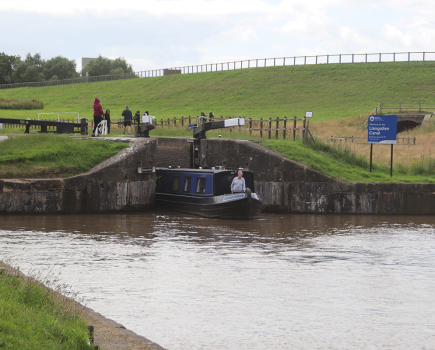
Our first morning was quite busy. After leaving Trenton, the waterway starts as a wide river, but narrows into a channel as it rises steeply through a series of six locks only about a mile apart. At the first lock, we had to tie up and pay for our seasonal one-way permit and for the lock-keeper to give us tips and information on good places to stay.

Below Campbellford, there is a deep ravine in the limestone where the Trent River goes into the Ranney Falls. Below the falls, the canal takes a sharp left into locks 11 and 12 – these form a double lock, so that as soon as you emerge from lock 11, you are straight into lock 12 without any intervening ‘pound’. Both locks are deep, providing a dramatic view from the top of the surrounding country.

The next day we intended to anchor somewhere quiet and peaceful, but it had become so hot (described as a ‘heat event’ on the local weather forecasts) that we decided to go all the way to Hastings. This meant we could stay in a marina with a power supply and have the boat’s air conditioner on.
We took the opportunity on the way to anchor in Seymour Lake and swim from the boat. Throughout the waterway, the water was crystal clear, thanks to Parks Canada’s very strict rules about what can be discharged from boats.

The municipal marina at Hastings is next to Pisces Park, a community development that opened in 2016. The vision is ‘to create Pisces Park as a cultural space with a series of fish sculptures of the types of fish found in the Trent River’. The first of these, Pisces Pete, by Canadian artist Bill Lishman, had been installed.


From Hastings, the river widens into Rice Lake, and halfway down the lake it takes a right into the Otonabee River, which leads to Peterborough. The town is actually on Little Lake, a bulge in the river. We had a challenging time docking at Peterborough, because the winds suddenly became very strong just as we arrived. The marina staff asked us to go to a finger dock, which involved making a sharp 90-degree turn to starboard.
The problrm was that Carina does not do 90-degree turns. She has a single screw engine and no bow thrusters. She stops at 45° and won’t do what she’s told in reverse, either. In strong winds, she goes into toy-throwing mode.

The young marina staff were polite and encouraging, but after several futile attempts at docking, with other boat owners looking on with trepidation, they gave in and let us go on the end of a T-dock, which involved only driving up to somewhere near enough for mooring ropes to be thrown to the waiting staff.
Morale was restored later when we had drinks with some other ‘Loopers’. They had a Marine Trader just like Carina and said they wouldn’t have even attempted trying to put the boat into a finger dock. A lesson learned.

Peterborough is famous for its Lift Lock, regarded as an engineering marvel. Two adjacent holding tanks simultaneously move in opposite directions, to take boats up and down the lock. No electric power is used and the lock works simply by the weight of water in the upper tank being greater than that of the lower one. The lift is 65ft – at the time it was built, in 1904, it was the largest structure in the world to be built from unreinforced concrete. It is very quick, too, as the ascent took only a couple of minutes.
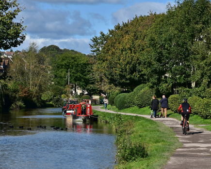
The Kawartha Lakes area is reputedly the most beautiful part of the waterway. Over the following days, we travelled through sparkling lakes and rivers, stopping at Lakefield, Buckhorn Lake and then Fenelon Falls.

Something that had puzzled us since arriving in Canada was the frequent reference to ‘loonies’. We imagined they were some sort of token, as there would be notices saying ‘loonies only’ in places like laundromats. At Fenelon Falls Laundromat, a lady enlightened us. Loonies turned out to be dollar coins, with the Queen on the front and a loon, an aquatic diving bird, on the back.
“Of course, we have toonies too,” she told us. “The two-dollar coin. They have a bear on the back, so we say they have the Queen on the front, with a bear behind.”
Another thing we had been wondering about was what peameal, which seems to feature on all breakfast menus in Canada, might be. I had a best-forgotten experience with grits in Charleston, and suspected that peameal might be something similar. But we went out for breakfast in Fenelon Falls and discovered it was lean Canadian bacon, thick-cut like gammon, and delicious.

The stretch of the Trent Canal beyond Mitchell Lake contained the Kirkfield Lift Lock, the highest point on the waterway. The lock was built to the same design as the one in Peterborough, but the height is only 49ft. It was still quite awe-inspiring though, to see the land and our westward journey stretching away from us as we waited for the lock to descend.
The next big thing was Lake Simcoe, a few miles further down the straight stretch of the Trent Canal. Although not as large as Lake Ontario, Simcoe is subject to capricious weather patterns and comes with a serious health warning. So we had to wait for a suitable window to present itself.
By now, it was sweltering. Strong winds and thunderstorms were forecast and we tied up at Lock 39 to sit it out because crossing Lake Simcoe in those conditions wasn’t an option. A hot, sticky night passed rather uncomfortably. The next day the winds and heat persisted but the thunderstorms didn’t materialise until the middle of the night, when we woke to the sound of heavy rain and a welcome drop in temperature. Although it was grey and raining, the winds weren’t too bad the next day, so we took a calculated risk and set off. The area around Portage Lock was agricultural and the scene not unlike many wet mornings on English canals.
The 15-mile crossing of Lake Simcoe took only two hours with the wind behind us. We skirted around the northern shore, passing through the Atherley Narrows before tying up at Bridgeport Marina, near Orillia, feeling rather guilty at the sight of the dockhands getting drenched as they helped us.

Above Orillia, the waterway passes through Couchiching Lake and Sparrow Lake and on to Big Chute, which is the most awesome thing on the waterway. It is not technically a lock, but a railway that transports boats up and down the rapids of the Severn River.
The boats sit on straps and are maintained in a horizontal position by a cunning two-rail system, which means the front of the boat is supported and moves down independently of the back. It was originally constructed as a temporary measure, pending a proper lock being built, but construction of the definitive lock was abandoned because of cost.


There were prominent notices about Parks Canada not being responsible for damage to boats, which was a bit worrying, but the experienced park staff told us exactly what to do and Carina was soon settled in the cradle. There were some slightly alarming noises as we descended, but all went well and we were out into the pool below the rapids surprisingly quickly.
Below Big Chute, we entered Little Chute Channel, a narrow, rocky pass with a strong current. Ian had to call ahead on the VHF to advise upbound boats of our presence. As a downbound boat we had right of way, but, as the Waterway Guide put it, ‘Upbound boats may not know this, or act accordingly’. There weren’t any boats and after the channel, the landscape opened out into the lovely Gloucester Pool, with its many islands.
The waterway ends at Port Severn, and suddenly we were through the last lock and out into the vast expanse of Georgian Bay, occupying the north-eastern part of Lake Huron. The bay is almost as big as Lake Ontario and has 30,000 islands festooning its northern shore. We had plenty more challenges ahead.
Image(s) provided by:
Archant