In the final part of our guide to the canal forming the backbone of the southern waterways, we cross the Chilterns and descend through many locks to the Thames…
We ended part two of our guide to the great waterway route from the Midlands to London at Marsworth Junction. Leaving the Aylesbury Arm branching off westwards on our right, we’ll now embark upon the final stage of the climb towards the Tring Summit.

In the deep and shady Tring summit cutting
Tring Summit
The third and highest of the three summits that the canal climbs over on its route from Birmingham to the Thames at Brentford, this was also the one that the canal’s operators found most difficult to keep supplied with water. It can still suffer from shortages after dry weather, despite the best efforts to improve its supplies over the past 200 years – you can see some evidence of these efforts in the form of an extensive system of reservoirs on your right, as you climb the flight of seven Marsworth locks which wind their way up to Bulbourne Junction. You can also spot surviving remnants of a couple of other aspects of the canal’s history – note the ‘double bridge’ immediately below the bottom lock, dating from when there were narrow locks built alongside the broad ones in use today, and also the water-saving sideponds (no longer in use) by each lock.
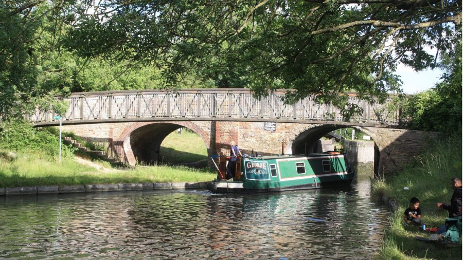
Bulbourne Junction is another reminder of the struggle for water supplies: it’s the start of the Wendover Arm, built as a navigable feeder but suffering from supply problems of its own. The summit level is only three miles long, and after passing the former Bulbourne lock gate workshops (currently being converted for residential use) and a handy waterside pub, most of those three miles are taken up by a long, tree-lined and rather gloomy cutting as the canal cuts through the Chiltern hills. Emerging from the cutting, Cowroast Lock (it shares its name with a nearby pub, now sadly closed) marks the end of the summit and the beginning of the long descent to the Thames.

Cowroast Lock, where the Tring summit ends and the long downhill journey to the Thames begins
The descent…
And a long and relentless descent it certainly is. There are no great flights of locks, many of them are singles or pairs – in fact quite a few of them are just that annoying distance apart that puts you in a dilemma regarding whether it’s worth the crew getting back on the boat between locks – but in the 35 miles to Brentford there are 57 of them with seldom more than a mile’s gap, lowering the canal from the 395ft high summit to sea level. Don’t let me put you off the southern Grand Union, though. It’s a pleasant route, with interesting towns and villages alternating with countryside, as the canal follows the valley of the rivers Bulbourne, Gade and Colne towards Watford – and all the locks are wide beam, so if you’re in a narrowboat there’s a good chance you’ll find somebody to share the locks and the work.
Cowroast Lock is followed by Dudswell, Northchurch, Bushes and the less romantically named Gas Locks (they were by the town’s gasworks) as the canal enters Berkamsted – not only a useful stopping point with shops and a couple of canalside pubs, but there’s also a ruined Norman castle to visit (see inset). As the canal leaves the town, you may notice a small watercourse joining from the right: we already mentioned that the canal follows the valley of the Bulbourne and other small rivers, but in various places it actually shares its course with them. This isn’t an issue most of the time, but after rain it can mean an appreciable current in some places.
Top Side Lock and Bottom Side Lock (Why were they called that? Was it something to do with being the only locks this side of the summit to have side ponds?) are followed by Sewer Lock (no such puzzles here – there’s a sewage works next to it) and Winkwell Locks, where there’s also a (key operated) road swingbridge for a bit of variety, with accompanying pub. A rural length ends as the canal runs through parkland skirting Hemel Hempstead, and the little River Gade joins from the left.
The mills
Still the locks continue, with Boxmoor, Apsley Mills and Nash Mills continuing the descent. The ‘mills’ in question were paper mills, which once provided a regular trade for the canal – but also gave the canal company a 15-year headache.

Apsley Locks continue the long descent
Sharing its course with the Gade and the Bulbourne brought the canal into dispute with the millers over water, with the mill owners demanding compensation from the canal company for diverting water from the rivers to feed the canal and stopping the mills from working in dry weather. A two-mile ‘long pound’ (well, that’s long by southern GU standards!) which suffered from leakage, followed by a flight of four deep (and therefore thirsty) locks didn’t help. Compensation claims, court cases, construction of a backpump, addition of sideponds, enquiries, and even tests conducted by Thomas Telford culminated in a court decision against the canal – and eventually the replacement of the ‘long pound’ and four deep locks by the present route through Apsley and Nash Mills using five shallower locks.
The mills have long ceased operation but in recent years the surviving buildings have been converted to new uses, while today’s scene is completed by a new marina basin, a striking new footbridge and a modern pub (named the Paper Mill in a nod to the past).
King’s Langley village (its lock bears the number 69A, a result of the extra lock added as described above) is followed by a concrete viaduct carrying the M25 over the canal, indicating our proximity to London – but you wouldn’t think it from the next length, featuring a series of long sweeping bends (take them carefully in a full-length boat) and a couple of delightful ornamental bridges as the canal passes through parkland. This was Grove Park, owned by the Earl of Essex, who would only allow the canal to be built across his land if it was suitably gentrified – and it’s followed by the attractive wooded length through Cassiobury Park, where the Earl of Clarendon similarly used his influence to good effect.

Striking modern bridge among what were once the paper mills of Apsley
Under the Underground
There’s another reminder that despite all this we really are only about 15 miles from central London in the form of a high railway bridge carrying the Metropolitan Line underground trains over the canal at Cassio Bridge. But that’s the distance ‘as the crow flies’: by the roundabout route the canal takes to follow the lie of the land, it’s more like double that distance.
It begins by turning south westwards, the locks continuing at roughly one-mile intervals to reach Rickmansworth, a useful stopping place. Here one of the shorter and less well-known branches of the canal comes in on the right through a separate lock alongside the main one. Navigable for a few hundred yards for moorings, it’s based on the River Chess and features a Grand Union oddity, a lift bridge, as well as (if you can discern them) some signs of where a further lock used to link to a gravel pit.

Leaving Uxbridge lock heading northwards
Former gravel workings are a feature of the next length, many of them flooded to form lakes alongside the canal as it runs past Harefield and Denham. Watch out for what can be a quite fierce weir stream coming in sideways below Coppermill Lock, and the aptly named Denham Deep Lock, whose 11ft rise is the greatest on the Grand Union.
The canal continues to skirt around London’s outskirts as it heads southwards past Uxbridge, followed by Cowley Lock – and this is where the crew finally get a rest from locks, as it’s the last one for six miles (in fact the last for 20 miles if you’re heading into central London). A marina accompanies the junction with the Slough Arm, then Yiewsley, West Drayton and Hayes continue the generally urban and sometimes industrial surroundings as far as Bulls Bridge Junction.

A rest for the crew: Cowley Lock is the last for six miles
Bear left for Paddington
Here the Paddington Arm turns off sharp left, while on the right is the ‘lay by’ where working boats in the large Grand Union Canal Carrying Company fleet used to tie up waiting for orders for their next load. The canal’s built-up surroundings continue as it runs eastwards to Norwood, where the locks begin again. Look carefully as you pass through the next bridge after the first two locks: this is the curious ‘Three Bridges’, where a road bridge spans the canal, which itself is carried on a small aqueduct over a railway – once the busy freight line serving Brentford Dock, now used by a couple of gravel and rubbish trains a day.
Next come the six locks in the main Hanwell sequence, and the first ‘proper’ flight of closely spaced locks since Marsworth – and they’re an attractive flight, leading steeply down the hill with the high wall of the former hospital on one side and heathland to the other. Note that some of them even had triple side-ponds – a reflection of their greater depth, and the importance of saving water, given the busy local traffic at the London end of the canal.
Follow the River Brent
Below the bottom lock the River Brent enters the canal, and the final couple of miles follow its gently winding course to Brentford. Look out for the sign marking where the team working on a section of piled canal wall won the Kerr Cup piling competition in 1969! And note the splendid cast iron footbridge taking the towpath over the canal just past the M4 motorway crossing – these Horseley Ironworks bridges are common on the Birmingham Canal Navigations and other midland waterways, but this must be the southernmost example by a long way.

On the final length of canal in Brentford leading to the Thames
The canal in Brentford used to be an industrial length surrounded by warehouses overhanging the water; now just one of these buildings has been preserved, while regeneration has brought housing to the rest of the canalsides. Brentford High Street’s shops and facilities are a short walk from below Brentford Gauging Locks.
This is almost the end of our journey – and for boaters who aren’t planning to continue onto the River Thames, there is plenty of room here to turn round ready for your return journey. But for those heading for the Thames, there’s another short length of canal and two locks to negotiate.
The paired Gauging Locks are power-operated by boaters using a CRT Watermate key; they lead onto a semi-tidal length which twists around past assorted moored craft of all sizes to reach Thames Locks. Here – subject to bookings and tide times – the keeper will lock you through, and you’ll leave the Grand Union behind for the journey up the tideway to Teddington, or the more adventurous trip downriver to Limehouse.
Image(s) provided by:
Martin Ludgate


