The Main Line, the backbone of the formerly heavily industrial BCN network which covers Birmingham and the Black Country, has seen many changes – from the 19th century straightening and modernisation of the route, to today’s waterside regeneration schemes.
Read our guide to Canal Boat’s pick of ten best pubs on the BCN Main Line here

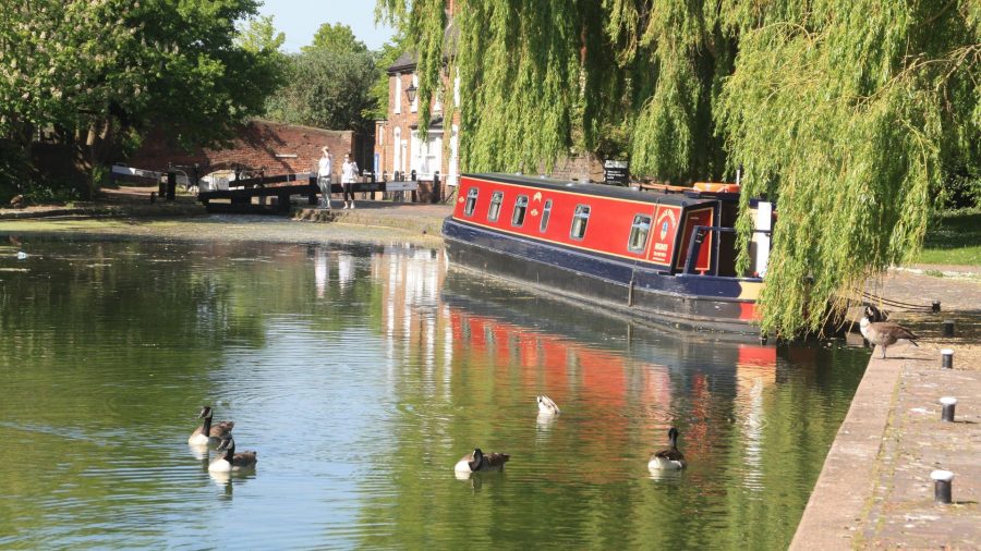
Perhaps it was the long sequence of locks heading inexorably upwards from Aldersley Junction into Wolverhampton as the main line of the Birmingham Canal Navigations begins its journey to Birmingham. Or maybe it was the fact that lead singer Robert Plant and drummer John Bonham hailed from the fringes of the Black Country. But for whatever reason, I had 1970s rock band Led Zeppelin’s classic Stairway to Heaven going through my head as I walked up the towpath of the 21-lock Wolverhampton flight.
I’m not sure that Heaven is entirely appropriate just yet, but it’s a flight that’s changed a great deal over the years, especially at the top end. It always used to be a two-mile transformation from the apparently rural surroundings of Aldersley Junction, where it leaves the Staffordshire & Worcestershire Canal (a waterway which somehow managed to retain its rural feel, despite skirting the edge of the built up area for several miles), past Dunstall Park and the racecourse, then via the housing estates of Wolverhampton’s suburbs, under assorted railway bridges, and finally to the industrial heartlands on the approach to the town centre. These days the lower locks still preserve their rural appearance, the racecourse and the residential areas are still there, but much of the industry which surrounded the upper locks has been replaced by warehousing, a science park and a conference centre, and what’s left is disappearing behind trees and vegetation which now flank much of the canal.

New waterside developments in Wolverhampton
Unlike (say) Hatton or Devizes locks, there aren’t any great impressive (or daunting, depending on your view) vistas of never-ending series of locks climbing into the distance; they’re more like the 30 at Tardebigge in the way that they wind this way and that, usually with two or three locks in sight at any one time. And being narrow locks, they aren’t too much hard work – especially as they have the paired bottom gates common on narrow canals elsewhere in the country, rather than the heavy single bottom gates which are a feature of many of the locks on the Birmingham Canal Navigations network. BCN aficionados will recognise that this identifies them as dating from the earlier years of canal construction in the Black Country: we are on the original Birmingham Canal, engineered by James Brindley and opened in 1772 from Aldersley Junction to Birmingham, which went on to form the backbone of what was at its greatest extent a 160-mile network covering Birmingham and the Black Country and reaching out to Cannock, Lichfield and Fazeley.
(Incidentally real BCN aficionados will note that unlike the other 20 locks, the second lock up from Aldersley does actually have a big single bottom gate rather than a pair, and surmise – correctly – that this lock was added during the middle years of Black Country canal building, when this form of construction had become the norm. The reason for adding an extra lock was to cut water consumption by reducing the depth of the very deep original bottom lock.)
Climbing the final few locks of the ‘stairway’, alongside the main line railway, leads not to Heaven but to a pleasant area with an old lock cottage and a small park surrounding the canal close to central Wolverhampton, with moorings to visit the city centre. The part of Wolverhampton close to the canal was a bit of a building site when we were there, with the main railway station being rebuilt and the tramway being extended through the city’s streets to serve it, but normally the shops, pubs and other attractions are within easy walking distance.
I mentioned earlier that we were on the original 1772 Birmingham Canal, and while that’s been true so far, on our way to Birmingham we will encounter many later deviations from that route. All-in-all, less than half of today’s journey along the New Main Line follows Brindley’s original line. The first short diversion is in the form of a long and tunnel-like bridge taking us under the approaches to Wolverhampton’s railway station, which replaced the canal’s original route when the station was built; we’ll see some much longer deviations as we continue.
The remains of the first few yards of the original route survived as a basin, which is still in water, with a warehouse (more recently used as a night club) bearing the name of famous canal carriers Fellows Morton & Clayton.
It introduces us to a couple more BCN features: the many short arms and basins which gave the canals direct access to so many industrial premises, and the distinctive cast iron bridges (many of them marked as coming from the Horseley Iron Works) which carried the towpath over the entrances to these basins. Many have long since been filled in, and it’s only the hump in the towpath as it crosses the site of the old bridge which indicates where they were. Leaving the city centre behind, the canal passes through an area which is currently still heavily industrial, but with parts earmarked for redevelopment. The Wyrley & Essington Canal begins its long and meandering journey across the northern Black Country at Horseley Fields Junction (the Horseley Ironworks that made the bridges was nearby), followed by more industry and old basins.
These include the former Chillington Railway Basin, another distinctive BCN feature. In the industrial West Midlands the arrival of the railways didn’t necessarily lead to the battle for trade between canal and rail which is recounted in many canal history books. Instead the railways concentrated on the longer distance traffic, accepted that the BCN’s dense network of arms, branches and basins gave it greater penetration into the heart of the industrial areas, and built a system of interchange basins for cargoes to be transhipped between rail and canal for the start or end of their journey. This kept the canals busy with local traffic until comparatively late on and this particular basin, in use by boats until the 1960s and for several decades longer for rail and road vehicles, is the last one surviving with its features – the travelling crane and canopy roofs over the silted up basin – still intact. It’s not exactly a thing of beauty, it’s not in good condition, and it’s not clear what its future might be, but it’s listed by Historic England which should afford it some degree of protection.

An increasingly leafy length of canal near Monmore
The canal twists and turns as it continues south east past Monmore Green and Ettingshall, the surroundings alternating between industrial, residential, and increasingly these days some pleasantly tree-lined reclaimed areas, while the winding course indicates that we’re still mainly on Brindley’s original line. That all changes, however, at Deepfields Junction where the Wednesbury Oak Loop branches off to the left under another cast iron towpath bridge. The name ‘loop’ is the clue: this was a meandering four-mile length of the original canal, following the contours as it wound its way through Bradley, which was replaced by a direct one-mile short-cut designed by Thomas Telford in the 1830s, the saving in time being worth the cost of cutting through the high ground by digging Coseley Tunnel. The first couple of miles as far as Bradley survive as a dead end, largely because they connect to a pumping station supplying the BCN with water from old mine workings, and to the Canal & River Trust’s lock gate workshops. One day, the Bradley Canal Restoration Society hopes to turn this back into a useful through route by opening the old Bradley Locks Branch, which used to connect it to the Walsall Canal near Moxley.

The eastern approach to Coseley Tunnel
Meanwhile back on today’s Main Line, Coseley Tunnel was ‘state of the art’ when opened, being wide enough for two boats to pass in, and equipped with not one but two towpaths. In fact the whole of this one-mile length has a clear ‘modern’ feel to it, its the straight course and the deep cuttings at either end of the tunnel adding to the contrast with the earlier sections. A right bend indicates where the original route rejoins (there’s no sign of an actual channel coming in), but after half a mile we reach Factory Junction where old and new routes split again.
This time, though, there’s a choice. Both the old route, meandering around Tipton Green and Oldbury, and the 1830s route running straight and wide alongside the railway through Dudley Port and Sandwell are still navigable. It’s tempting to say “take the new Main Line if you’re interested in trains, the old main line otherwise”, but they both have plenty of interest, they both have connections to other canals which might affect your choice, and in fact there are two links between them so you can always change your mind later. And of course, that got me thinking of Stairway to Heaven again… as Messrs Plant & Co would put it “Yes there are two paths you can go by, but in the long run, there’s still time to change the road you’re on…”
Taking the New Main Line first, it leaves Factory Junction and immediately drops down the three Factory Locks, formerly amid industrial surroundings but now looking positively leafy. Look out for a couple of features: a split bridge (one with a gap to pass the towrope through in horse-boating days) crosses the bottom lock, but unusually the gap is at one side rather than in the middle. And the flight of locks is laid out so that the towpath side of the canal forms a continuous straight line all the way through the three locks and the intervening short pounds (a feature it shares with the six locks on the Titford Canal).

A quiet fishing spot at Albion Junction on the New Main Line
The locks lower the canal to the ‘Birmingham Level’ – an expression used in BCN terminology to refer to the extensive mileage of canals on the 453ft contour, which extend from here all the way to Birmingham and beyond, out to Tardebigge on the Worcester & Birmingham Canal, and Lapworth on the Stratford, as well as through Netherton Tunnel to Blowers Green. The New Main Line continues dead straight, with towpaths on both sides, past the former Watery Lane Junction (where it was once crossed by the curiously named Tipton Green and Toll End Communication, which formed another cross-connection between the Old and New Main Lines) and on to Dudley Port Junction. Here the Netherton Tunnel Branch turns off sharp right, heading for the Dudley and Stourbridge canals. All of these junctions are marked by iron towpath bridges, and often there is a ‘toll island’ nearby: these islands in the canal, with a narrow channel on each side, were originally the site of small toll-houses where working boats were checked for tonnage tolls to be charged.
(Incidentally we couldn’t help noticing that some kind person had neatly painted the word ‘Hell’ on the towpath bridge at Dudley Port Junction, accompanied by an arrow pointing towards Netherton Tunnel. Keeping with the rock music theme, we’ve heard of the Road To Hell and the Highway To Hell, but not the Towpath To Hell!)

On the Old Main Line near the Dudley Tunnel junction
Meanwhile back at Factory Junction the Old Main Line, sticking to the 473ft contour (known as the ‘Wolverhampton Level’ and also covering an extensive mileage of water, extending all the way up the Wyrley & Essington to Anglesey Basin among other places) winds southwards to Tipton Junction where the Dudley Canal heads off through Dudley Tunnel. Very narrow, low and unventilated, this early bore is now restricted to the Dudley Canal & Tunnel Trust’s tripboats (see inset) plus sufficiently low profile craft which can be hauled through by electric tug. But for most visiting boaters the canal’s main function is for access to moorings for the Black Country Museum, an outdoor museum recreating an industrial town from buildings dismantled and rebuilt on the site, with trams, a coal mine, a canal wharf and a pub.

Tividale on the Old Main Line
The Old Main Line now heads south eastwards, crossing the Netherton Tunnel Branch on the Tividale Aqueduct, where once a water turbine (driven by a pipe carrying water between the two canals) generated electricity to power the lights which used to illuminate Netherton Tunnel. Next comes Bradeshall Junction, where the Gower Branch provides a link to the New Main Line – featuring the only pair of staircase locks on the BCN. (Lovers of BCN trivia will note that they have single gates throughout, making them the only example in the country of two locks with a total of only three gates between them!)
Returning to the New Main Line, it continues to accompany the main line railway, past Albion Junction (where the Gower Branch comes in) to Pudding Green Junction. Here, a sharp left turn leads into the Wednesbury Old Canal, leading to the Walsall Canal and another route to the northern part of the BCN network. At yet another junction at Bromford, the Spon Lane Locks (of which more later) bear off to the left, while up ahead we can see a multi-level combination of bridges involving the M5, the railway, the New Main Line and the Old Main Line.
Meanwhile, the Old Main Line skirts Oldbury where a sharp right turn at Oldbury Junction leads to the Titford Canal: its six locks climb to what is now the highest navigable level on the BCN, passing the historic pumphouse which houses the BCN Society’s headquarters, before ending at Titford Pools. We could describe these as “a small canal reservoir spanned by a concrete viaduct carrying the M5 motorway”, but it’s actually worth a visit, the formerly silted pools recently dredged out and navigable, and the area benefiting from a package of nature and wildlife improvements.
The M5’s influence is felt rather more strongly back on the Old Main Line, which runs underneath the motorway for some distance (you get a great view of the work being carried out to shore up and repair the deteriorating 1960s structure) as it approaches the multi-level bridges mentioned above. The Old Main Line crosses over the New Main Line on Steward Aqueduct; the railway runs alongside the New Main Line at a higher level, bridging the Old Main Line; and the motorway runs at the topmost level, striding over everything. And in among it all is Spon Lane Junction, where the Spon Lane Locks provide the second interconnection between the old and new lines. Confused? See our map.

On the Old Main Line approaching Summit Tunnel, created when a new road was built in the 1970s
Old and new lines now run parallel and close together but at different heights, with the New Main Line in a deep cutting. Thomas Telford’s Galton Bridge spans this cutting, but sadly the view of this elegant and impressive structure was rather spoilt in the 1970s by the construction of a massive new road embankment crossing both canals. So massive, in fact, that rather than new bridges it crosses the canals on two new concrete tunnels (even if they weren’t actually tunnelled through the ground – so perhaps technically they’re just long bridges – they certainly look like tunnels). Galton Tunnel carries the New Main Line, Summit Tunnel the Old.
Look out for the tall chimney of the old Brasshouse Lane pumping station, which once lifted water supplies between the two canal levels, and then for the Engine Arm, a navigable feeder which branches off the Old Main Line and crosses the New Main Line on a cast iron aqueduct by Thomas Telford. The three Smethwick Locks (note the replica toll house by the top lock, recently rebuilt after damage in an arson attack – let’s hope it lasts longer this time) finally bring the Old Main Line down to the Birmingham Level, and the two lines meet at a junction with a pair of cast iron towpath bridges.

Near Smethwick, typical BCN iron towpath bridge in distance
Leaving Smethwick behind, we’re into the last couple of miles into Birmingham, and another heavily industrial area, much of which is being transformed – some of it quite rapidly – by modern developments. The canal follows a straight and direct course, but three lengths cut off by the straightening of the original canal survive as navigable loops, and are all worth a detour. First is the Soho Loop, passing another former railway interchange basin now used as residential moorings at Hockley Port. The first signs of modern redevelopment accompany the end of this loop as it crosses straight over the main line (at a junction with no fewer than three towpath bridges) into the Icknield Port Loop. Or, to use its full name, the Icknield Port Road Wharf Loop – I can’t help thinking it must have been vying with the Tipton Green and Toll End Communication for the “longest name for shortest canal” trophy! Anyway it’s the scene of extensive redevelopment, with new housing rapidly replacing the former industrial land within the loop.

An apparently rural scene by the Soho Loop
Finally there’s the Oozells Street Loop, and by now we’re approaching the city centre with modern commercial, residential and leisure developments facing the canals on all sides. The Oozells Street Loop ends at a complex junction where the main line turns right, while the link to the Birmingham & Fazeley Canal bears off left. BCN purists will tell you that it’s actually two junctions – one called Deep Cuttings and the other Old Turn – and there’s a third junction called Farmers Bridge Junction where the Birmingham & Fazeley Canal begins above Farmers Bridge Locks. Oh, and there are another three towpath bridges, plus a fourth footbridge added in recent years – and a small island in the canal to make the turn more interesting.

Modern developments surround the junction with the Oozells Street Loop. A longer boat would struggle to get round that turn!
The final length of the BCN Main Line passes through the heart of the Brindley Place redevelopment, with shops, bars and restaurants, the Sea Life Centre, the National Indoor Arena, International Convention Centre and more, in a lively atmosphere that’s a far cry from the what was until the 1980s a rather unkempt industrial canalside area (albeit one with a great character all of its own).
The final few yards of BCN Main Line lead to Gas Street Basin, where the Worcester Bar originally formed a physical barrier between the BCN and the Worcester & Birmingham Canal, as dictated by the Act of Parliament (for reasons of inter-canal rivalry) until common sense prevailed and a shallow stop-lock was built to link them together. This lock has for many years been left open at both ends and you cruise straight through onto the W&B. But before you do, look back at the rather cavernous bridge you’ve just passed under. It’s variously referred to as Broad Street Bridge or Broad Street Tunnel (it was considerably longer, with a church built on top of it, until around the 1990s); but it now has a new name.
As a new commemorative bench (a heavy metal one, naturally) on top of the bridge proclaims, this bridge is named ‘Black Sabbath Bridge’ in honour of Brum’s famous rockers, whose original line-up are pictured as part of the monument. So a cruise that began with Robert Plant ends with Ozzy Osbourne.

Old Turn Junction: Bear left through the bridge for the Birmingham & Fazeley, right for Gas Street,
Image(s) provided by:
Martin Ludgate


